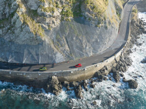
In 2019 a large weather event led to widespread damage on the West Coast, including exposing a disused landfill on Fox River. This led to rubbish being released and spread along a large area of coastline. The event prompted a ministerial question of “how many more landfills are at potential risk in New Zealand”. A multi-disciplinary team was set up to answer this.
Working with Environment Canterbury and the Ministry for the Environment, T+T undertook a pilot study using data from three regions (West Coast, Southland, Canterbury) to develop a risk assessment tool that could be used nationally to prioritise closed landfills in terms of their exposure and vulnerability to climate change related natural hazards (river and coastal flooding, erosion and scour).
The key components of the assessment were:
- exposure of the landfill to natural hazards now and under future climate change scenarios;
- vulnerability of the landfill based on construction, condition and known issues
- criticality of the landfill based on its contents, including size, waste type, proximity to sensitive environments.
T+T developed an interactive dashboard that allowed organisations to view their ranked landfills by risk, based on the:
location of landfills against available hazard information to establish exposure.
Established assessment criteria to rate vulnerability and criticality .
Data quality information, based on the completeness of supplied Council information.
The assessment highlighted the variability in data completeness, both landfill information and hazard information, which has direct impact on the level of certainty of the tool.
Further development of the tool is required before it can be adopted across NZ and fulfill its potential as a national management tool. For one of the councils involved in the pilot, a potential next step is the development of an interactive version of the tool that can be updated by council staff in the light of new information (e.g. site visits).


