


Australasian Coasts & Ports 2021 Conference, Christchurch
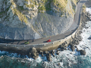
A magnitude 7.8 earthquake struck the Kaikōura coastline in November 2016 causing widespread uplift and landslides closing State Highway 1 and Main North Rail Line. Ōhau Point was the location one of the largest and most challenging landslides, with more than 160,000 cubic meters of rock falling from the surrounding cliffs and inundating the road and rail corridors. Show more…Recovery works by the North Canterbury Transport Infrastructure Recovery (NCTIR) Alliance reinstated the roadway further seaward and at a lower level than previous due to residual landslide and rockfall risk. A unique combination of steep offshore bathymetry and rock outcrops resulted in focusing of wave energy and overtopping to occur at a higher frequency and magnitude than was initially expected. This overtopping presented a potential hazard to road users and to the road infrastructure itself during extreme events. This paper presents the results of extensive physical modelling undertaken at the Water Research Laboratory at UNSW Sydney to investigate the overtopping processes and to assist NCTIR in evaluating options for mitigating hazard at the site. The section of road and seawall at the site is fronted by a nearshore zone with highly complex bathymetric features, and as such, a quasi-threedimensional model was required to simulate the complex 3D effects of the nearshore wave field and overtopping process.Show less…